Detecting Environmental Changes: CEC Releases 2015-2020 North American Land Cover Change Map
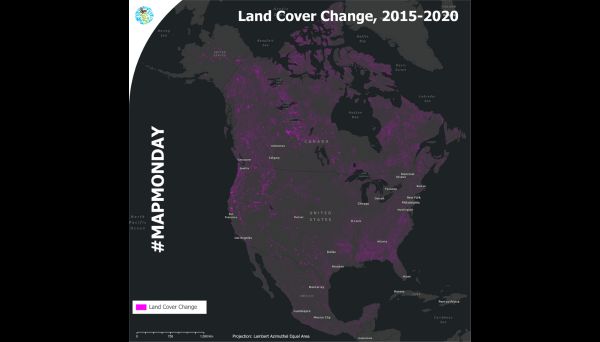
Montreal, 19 July 2023 — The Commission for Environmental Cooperation (CEC) is proud to release the 2015–2020 North American Land Cover Change map, under the North American Land Change Monitoring System (NALCMS), a collaboration with the Governments of Canada, Mexico and the United States and their respective mapping agencies. This land cover change product offers the most accurate information available at this scale and is publicly available through the North American Environmental Atlas.
Why is the 2015–2020 North American land cover change product important?
Detecting changes in land cover can help us identify areas where issues like deforestation, biodiversity loss and urban sprawl are occurring.
Large environmental shifts can be perceived by satellites and then categorized to show how our environment transforms over time. For example:
Forest cover destroyed by wildfires (e.g., from forests to grasslands or barren lands)
- Agricultural expansion (e.g., from forests or wetlands to croplands)
- Urban sprawl (e.g., from any category to urban areas)
“This product can be used to better protect and conserve critical ecosystems such as wetlands, grasslands and forests. It can help researchers and decision-makers analyze the changes in our shared environment and ecosystems across the continent, and help us see what needs to be done to protect them,” said Dominique Croteau, CEC Project Lead for Geospatial and Environmental Information.
Land cover refers to the classification of surface cover on the ground, whether forest, urban infrastructure, bodies of water, or agricultural land, etc., which helps to distinguish natural and anthropogenic features. Identifying, delineating, and mapping land cover (or land use) is important for global, regional and local monitoring studies, resource management, and planning activities. Land cover classes can include natural features such as forest, shrubland, grassland, and water bodies, but also human-made features, such as urban areas and cropland. Land cover change refers to the change in these classes over time for a specific area.
North American Land Change Monitoring System
This map was produced through the CEC’s North American Land Change Monitoring System (NALCMS), a collaborative initiative with Natural Resources Canada (NRCan)’s Canada Centre for Mapping and Earth Observation (CCMEO), the United States Geological Survey (USGS), and three Mexican agencies: the National Institute of Statistics and Geography (Instituto Nacional de Estadística y Geografía—INEGI), the National Commission for the Knowledge and Use of Biodiversity (Comisión Nacional para el Conocimiento y Uso de la Biodiversidad—Conabio), and the National Forestry Commission (Comisión Nacional Forestal—Conafor).
North American Environmental Atlas
The NALCMS land cover mapping products are available through the CEC’s North American Environmental Atlas, a collection of harmonized geospatial data from Canada, Mexico and the United States, giving a continental perspective on transboundary environmental issues. Thematic map layers allow the visualization of various environmental aspects, such as terrestrial and marine ecological regions, climate zones, as well as protected areas across the three countries.
If you would like to learn more about CEC initiatives, you can sign up for our newsletter and follow us on social media.
Over time, the cumulative impacts of environmental changes caused by forest fires, resource extraction or the expansion of agricultural, industrial and urban areas can transform our world. The 2015–2020 North American Land Cover Change product can provide insights to support environmental action and policy.
About the CEC
The Commission for Environmental Cooperation (CEC) was established in 1994 by the governments of Canada, Mexico and the United States through the North American Agreement on Environmental Cooperation, a parallel environmental agreement to NAFTA. As of 2020, the CEC is recognized and maintained by the Environmental Cooperation Agreement, in parallel with the new Free Trade Agreement of North America. The CEC brings together a wide range of stakeholders, including the general public, Indigenous people, youth, nongovernmental organizations, academia, and the business sector, to seek solutions to protect North America’s shared environment while supporting sustainable development for the benefit of present and future generations
The CEC is governed and funded equally by the Government of Canada through Environment and Climate Change Canada, the Government of the United States of Mexico through the Secretaría de Medio Ambiente y Recursos Naturales, and the Government of the United States of America through the Environmental Protection Agency.