CEC Releases New Digital Land Cover/Land Use Map of North America, Most Accurate Available at This Scale
Montreal, 20 March 2023 — The Commission for Environmental Cooperation (CEC) is pleased to release the latest trinational digital land cover map of North America, under the North American Land Change Monitoring System (NALCMS), a collaboration with the Governments of Canada, Mexico and the United States and their respective mapping agencies. This land cover map is the most accurate map available at this scale and is publicly available through the North American Environmental Atlas.
“We at the CEC are proud of this new digital map, comprising approximately 24 billion pixels, and depicting land cover across North America for the year 2020 at a 30-meter spatial resolution. It is derived from USGS’s Landsat satellite imagery and cross-checked with ground observations for accuracy, making it the most accurate land cover map at the North American scale,” said Dominique Croteau, CEC Project Lead for Geospatial and Environmental Information.
Land cover refers to the classification of surface cover on the ground, whether forest, urban infrastructure, bodies of water or agricultural land, etc., helping to distinguish natural and anthropogenic features. Identifying, delineating, and mapping land cover (or land use) is important for global, regional and local monitoring studies, resource management and planning activities. Land cover classes can include natural features such as tropical forest, shrubland, grassland, and water bodies, but also human-made features such as urban areas and cropland.
This new land cover map, presented by the CEC, harmonizes land cover classification into 19 comparable classes across Canada, Mexico and the United States. The NALCMS land cover classes are based on the Land Cover Classification System (LCCS) standard developed by the Food and Agriculture Organization (FAO) of the United Nations.
“People can appreciate that land cover information is necessary for a large range of applications related to environmental decision-making, natural resource management, adaptation to climate impacts, emergency response, environmental conservation and restoration and many more. Our goal with the North American land cover product is to support policy- and decision-makers, researchers, international and intergovernmental organizations, NGOs, land managers, among many others, from local to global, by allowing them to better understand the dynamics and patterns of North America’s land cover and to conduct both regional and local-level analyses,” concluded Croteau.
North American Land Change Monitoring System
This map was produced through the CEC’s North American Land Change Monitoring System (NALCMS), a collaborative initiative with Natural Resources Canada (NRCan)’s Canada Centre for Mapping and Earth Observation (CCMEO), the United States Geological Survey (USGS), and three Mexican agencies: the National Institute of Statistics and Geography (Instituto Nacional de Estadística y Geografía—INEGI), the National Commission for the Knowledge and Use of Biodiversity (Comisión Nacional para el Conocimiento y Uso de la Biodiversidad—Conabio), and the National Forestry Commission (Comisión Nacional Forestal—Conafor).
North American Environmental Atlas
The NALCMS land cover mapping products are available through the CEC’s North American Environmental Atlas, a collection of harmonized geospatial data from Canada, Mexico and the United States giving, a continental perspective on transboundary environmental issues. Thematic map layers allow the visualization of various environmental aspects, such as terrestrial and marine ecological regions, climate zones, as well as protected areas across the three countries.
If you would like to learn more about CEC initiatives, you can sign up for our newsletter and follow us on social media.
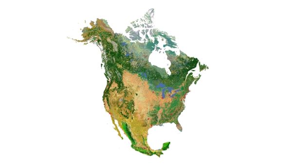
High quality 2020 North American land use/land cover digital map for use in research, environmental management and decision-making now publicly available in the North American Environmental Atlas.
About the CEC
The Commission for Environmental Cooperation (CEC) was established in 1994 by the governments of Canada, Mexico and the United States through the North American Agreement on Environmental Cooperation, a parallel environmental agreement to NAFTA. As of 2020, the CEC is recognized and maintained by the Environmental Cooperation Agreement, in parallel with the new Free Trade Agreement of North America. The CEC brings together a wide range of stakeholders, including the general public, Indigenous people, youth, nongovernmental organizations, academia, and the business sector, to seek solutions to protect North America’s shared environment while supporting sustainable development for the benefit of present and future generations
The CEC is governed and funded equally by the Government of Canada through Environment and Climate Change Canada, the Government of the United States of Mexico through the Secretaría de Medio Ambiente y Recursos Naturales, and the Government of the United States of America through the Environmental Protection Agency.